Explor Resources Inc. ("Explor" or the "Corporation") is pleased to announce the completion of the Phase 1 2013 Exploration program on the Chester Copper Property. An extensive ground exploration program was conducted on the Chester property, concentrating mainly west side of the Clearwater Stream in an area that has not been explored since the late 1950's.
The purpose was to explore the possibility of finding additional near surface mineralized zones similar to the known Chester Copper and VMS zones since it has already been confirmed (First Narrows 2004 and Historical drilling in 1967‐68) that the main zone Copper Stringer deposit exists for 500 to 700 metres west of the calculated resource as shown on the attached Soil Copper Geochemical Survey Map (available at the following address: http://media3.marketwire.com/docs/915267a.pdf).
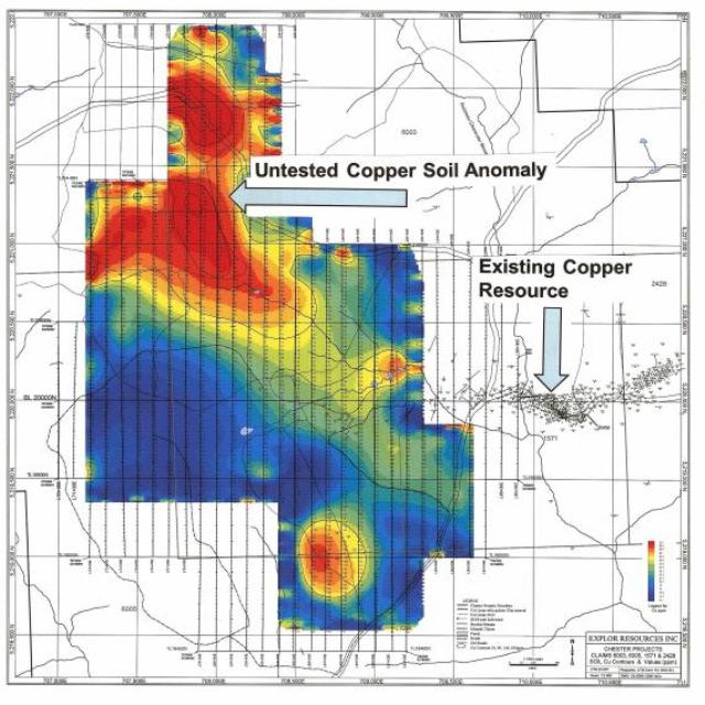 Soil Copper Geochemical Survey Map
The 2013 work program consisted of a grass roots exploration program briefly described as follows:
- Line cutting, or grid establishment. A total of 74.7 kilometers of lines were cut and chained;
- Geological Mapping. The entire grid was walked and mapped in July and August searching for outcrops, boulders and mineralization. Stream sediment samples were also taken as required. The objective was to search for sections of the favorable mineral bearing (or ore bearing) horizons at surface to the west of the known mineralization. The objective of the program was to correlate the underlying rock types with current knowledge and published maps of the Bathurst Mining Camp. During the mapping program a new zone of sericitization was discovered coincident with a very strong lead‐in‐soil anomaly. Following this anomaly along strike well defined Clearwater Stream rocks, altered and unaltered, were found south of the soil anomalies on several lines, defining considerable strike length. The identification of this rock type, which hosts the known Chester VMS and Copper stringer deposits, is very important in defining exploration potential of this property;
- Ground magnetometer and VLF EM surveys were conducted on the grid to be used as a mapping tool for later interpretations of the geological and geochemical results;
- A program of soil sampling the "A" & "B" horizons was completed on the newly established grid. No record of a soil sampling survey was found in any of the older assessment files, with the exception of the QPX soil survey of about 8‐10 years ago.
The soil survey ended up being a 2 phase survey with 1993 soil samples taken in the first phase. The samples were screened to ‐80 mesh (a standard sieve in the Bathurst Mining Camp) and analyzed by ICP by Activation Laboratories Limited of Ancaster, Ontario. Anomalies for copper, lead and zinc were outlined. An additional 1364 samples were taken on the grid and on compass lines in October to complement as well as to expand on anomalies from the first phase. A total of 19 stream sediment samples and 10 rock samples were also taken during the mapping phase and analyzed.
A quick review of the geochemical data indicates that there is one relatively small soil geochemically anomalous area for copper where 3 old drill holes dating to about 1958 or 1959 have been located. Three (3) other anomalous areas for Copper were identified as shown on the attached Soil Copper Geochemical Survey Map. In the northwest area of the grid there is a copper anomaly in soils as well as in local seasonal drainage streams. This anomaly is near the center of the grid and at the top of a hill. From the top of the hill it drapes to the west down a west‐dipping slope, and then trends to the southeast, also down slope and drainage to the east. To the east it is coincident with a lead anomaly and a zinc anomaly. Lead, being the least mobile of the 3 metals, follows a southeast trend for a strike length of more than 700 meters from west to southeast crossing 5 of the grid lines. This is a possible strike length of up to 900 meters from NW to SE but it is also down‐ice direction so it may be stretched out a bit. At the west end of the anomaly, for 1 line, the drainage is down slope to the west but in the middle the drainage, and ice direction is to the southeast. The soil anomaly is also associated with a ground magnetometer survey anomaly and a ground VLF anomaly. Favourable volcanic rocks on the south side with basement rocks on the north side indicating an interpreted major thrust fault. Another coincident copper and lead anomaly occurs in the central southeast zone of the gridded area. It is at about the same elevation as the main anomaly mentioned above but there is a valley between them and it is slightly in the up‐ice direction. Favorable alterations of the bedrock have been observed in the area of this anomaly during mapping and there were several historical shallow drill holes from 1956‐1959 reported in this area with random copper values. Additional soil sampling has been completed in that area but those results are not yet available. However, even without the additional soils data, there is a significant untested soil anomaly, a scarcity of outcrops, and potentially favorable geology that warrants a few test drill holes.
Explor plans on conducting additional ground geophysical work consisting of a Max/Min survey over the main lead and copper anomalies as well as a few test lines over other soil anomalies, and possibly a gravity survey over the best Max/Min anomalies. The phase 1 exploration program has determined numerous near surface, as well as deep, exploration targets on the Chester claim group west of Clearwater Stream. This area is an area that has not been explored by grass roots methods since about 1959. The soil sampling and modern soil geochemical analytical procedures have proven to be invaluable in this program so far in defining targets in favorable geology which can be further tested and refined by the previously stated geophysical program followed by diamond drilling.
Explor also announces that it has, subject to regulatory approval, retained Venture Liquidity Providers Inc. (VLP) to initiate its market-making service to provide assistance in maintaining an orderly trading market for the common shares of the Corporation. The market-making service will be undertaken by VLP through a registered broker, W.D. Latimer Co. Ltd., in compliance with the applicable policies of the TSX Venture Exchange and other applicable laws. For its services, Explor has agreed to pay VLP $5,000 per month for a period of 12 months. After an initial three-month period, the agreement may be terminated at any time by the Corporation or VLP. Explor and VLP act at arm's length, and VLP has no present interest, directly or indirectly, in the Corporation or its securities. The finances and the shares required for the market-making service are provided by W.D. Latimer. The fee paid by Explor to VLP is for services only. VLP is a specialized consulting firm based in Toronto providing a variety of services focused on TSX-V-listed issuers.
Chris Dupont P.Eng is the qualified person responsible for the information contained in this release.
Source: http://www.explorresources.com